

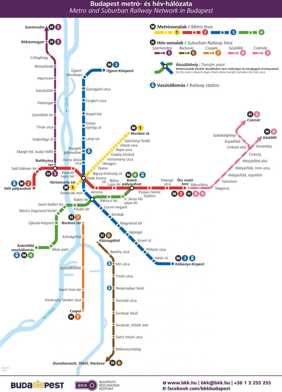
You can find on this page the Budapest metro map to print and to download in PDF. The Budapest metro map presents the network, zones, stations and different lines of the metro of Budapest in Hungary.

The Budapest metro map shows all the stations and lines of the Budapest metro. This metro map of Budapest will allow you to easily plan your routes in the metro of Budapest in Hungary. The Budapest metro map is downloadable in PDF, printable and free.
The Budapest Metro (Hungarian: Budapesti metró ) is the rapid transit system in the Hungarian capital Budapest . It is the second oldest underground metro system in the world, only the London Underground pre-dates it. Its iconic Line 1 , dating from 1896, was declared a World Heritage Site in 2002. Line 1 (Budapest Metro) , Line 2 (Budapest Metro) , Line 3 (Budapest Metro) , and Line 4 (Budapest Metro) as you can see in Metro map Budapest. The Metro consists of three lines, each designated by a number and a color. Metro Line 4 is currently under construction; the first section is scheduled to open in 2014. Line runs northeast from the city center to City Park along Andrássy Avenue .BKV metro symbol.svgBKV m 1 jms.svg. Line runs generally east to west from the transit hub Örs vezér Square on the city east side, and provides a connection between Keleti railway terminal and Déli railway terminal through the city center. Line runs northwest from the transit hub Kőbánya-Kispest in the city southeast, along Üllői Avenue to the city center, and then north to the district of Újpest.
Except for short stretches near the depots of each line, the system is mostly underground. All lines converge at Deák Ferenc square in the city center, forming the system only transfer station. This bottleneck is to be remedied by the opening of Line 4, which will cross Line 2 and Line 3 at different stations as its shown in Metro map Budapest. Line will run southwest to northeast from the transit hub of Budapest Kelenföld railway station in the city most populous district of Újbuda across the inner city district of Józsefváros to Keleti railway terminal .BKV metro symbol.svgBKV m 4 jms.svg. The Metro forms a separate system from the Budapest HÉV commuter rail, though Line 2 of the Metro provides transfers to the termini of two of the four HÉV lines. Integration of the incompatible HÉV system into the Metro is a long-term goal, and forms the basis of the proposed Line 5.
The first metro line was conceived as a means of carrying passengers from the city center to the City Park without the need for surface transport on Andrássy Avenue as its mentioned in Metro map Budapest. The Diet of Hungary approved the metro project in 1870. Construction began in 1894 and was carried out by the German firm Siemens & Halske AG, employing 2,000 workers using state-of-the-art machinery. The line was built entirely from the surface using the cut-and-cover method. Completed on schedule, the metro was inaugurated on May 2, 1896 (the year of the thousandth anniversary of the arrival of the Magyars ) by Emperor Franz Joseph. The original line followed a northeast-southwest route along Andrássy Avenue from Vörösmarty Square to the City Park, a distance of 3.7 kilometers (2.3 mi). There were a total of eleven stations, with nine underground and two above ground; the original terminus at the Zoo has since been replaced. With trains running every two minutes, the line was capable of carrying up to 35,000 passengers per day.

The Budapest subway map shows all the stations and lines of the Budapest subway. This subway map of Budapest will allow you to easily plan your routes in the subway of Budapest en Hungary. The Budapest subway map is downloadable in PDF, printable and free.
There are currently 4 subway lines in Budapest that provide service to the city centre and some of the outskirts of the city as you can see in Budapest subway map. There are several stops that would be of interest to travelers and tourists. Line 1 | Yellow Line: Runs from Vörösmarty tér to Mexikói út. Includes stops at Hungarian State Opera House, Heroes Square, City Park and the Chain Bridge. Line 2 | Red Line: Runs from Buda Déli Pályaudvar to Pest Örs vezér Square. Includes stops at the Hungarian Parliament, Kossuth Square, Batthyány Square, and the Great Synagogue. Line 3 | Blue Line: Runs from Újpest városközpont to Kőbánya, Kispest. Includes a stop at the Great Market Hall, St. Stephen Cathedral, the Hungarian National Museum and more. Connects with bus 200E (airport transfer). Line 4 | Green Line: Runs from Keleti Railway Station to Kelenföld Railway Station. Includes stops at Bikás park, the Gellért Thermal Baths, the Hungarian National Museum, the Great Market Hall, and more. The subway opens every day at 4:30 am and runs until 23:00 (11 pm) at night. You can expect metro trains to make stops every 2-15 minutes on average depending on the time of day.
Budapest metro line 2 has undergone major reconstruction, with much of the track and eight stations already completed. Blaha Lujza tér and Kossuth Lajos tér were renovated in 2004; Batthyány tér , Astoria , and Keleti pályaudvar in 2005; and Déli pályaudvar , Moszkva tér (Name restored to Széll Kálman tér on 12 May 2011), and Deák Ferenc tér in 2006 as its shown in Budapest subway map. These are currently the most modern stations in Budapest. Elevators will be installed at Kossuth Lajos tér, Blaha Lujza tér, Keleti pályaudvar, and Astoria, and new air-conditioned carriages will be ordered. Line 4 will connect southwest Budapest ( Buda ) to northeastern Budapest ( Pest ). The first section between Kelenföldi Railway Station and Eastern Railway Station , with a length of 7.5 kilometers (4.7 mi), is due to be completed earliest in late 2014, comprising ten stations. The construction of the second section (with four stations) between Eastern Railway Station and Bosnyák Square, with a length of 3 kilometers (1.9 mi), is not started yet. Site preparation at Bartók Béla Street and Fehérvári Street took place between 2002 and 2004.
Line 5 is in the early planning stages. It will most likely run along the Danube (crossing it at Margaret Island ), connecting with suburban railways going north and south. There is currently no planned start date for operation. There are plans for the extension of Line 3 towards the north (Káposztásmegyer) and the southeast ( Ferenc Liszt Airport ), perhaps also within the current decade as its mentioned in Budapest subway map. An extension to Ferenc Liszt airport has been made unlikely by the introduction of a train connection between the airport and the Western Railway Station. Currently, the only transfer point between the lines is Deák tér, however, forthcoming lines are to have other transfer stations. Line 4 will cross Line 2 and Line 3 at different stations. The Budapest Metro is completely electrified and standard gauge in operation. Three different types of rolling stock are currently in service: 3-car articulated-units locally built by Ganz on M1. Russian made Metrovagonmash sets on M2 and M3 line (which appear in many metros in former Soviet Bloc ). Fully automated Alstom Metropolis sets will operate on the M4 line (some operating also on M2).