

You can find on this page the Budapest neighborhood map to print and to download in PDF. The Budapest districts map presents quarters, region, suburbs and surrounding area of Budapest in Hungary.
The Budapest districts map shows all quarters and suburbs of Budapest. This district map of Budapest will allow you to discover areas and the region of Budapest in Hungary. The Budapest districts map is downloadable in PDF, printable and free.
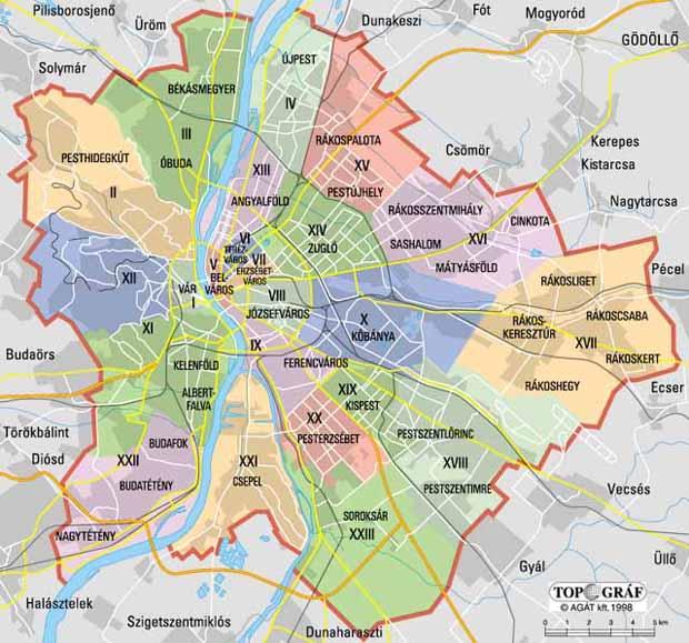
Originally Budapest had 10 districts after coming into existence upon the unification of the three cities in 1873. On 1 January 1950 Budapest was united with several neighboring towns and the number of its districts was raised to 22 (Greater Budapest) as you can see in Budapest districts map. At that time there were changes both in the order of districts and in their sizes. Now there are 23 districts, 6 in Buda, 16 in Pest and 1 on Csepel Island between them. Each district can be associated with one or more city parts named after former towns within Budapest. The city centre itself in a broader sense comprises the 5th, 6th, 7th, 8th, 9th and 13th districts on the Pest side, and the 1st, 2nd, 11th and 12th on the Buda side of the city. Some of the city districts are also twinned to small cities or districts of other big cities, for details see the article List of districts and towns in Budapest.
Budapest is not just split into Buda and Pest by the Danube River. In fact, there are 23 numbered municipal districts (kerület in Hungarian), that spiral out in a more or less in a clockwise trajectory from Buda Castle. The Royal Palace of Buda Castle is the city number one landmark. The palace is situated on Castle Hill, which is the where the area got its name from as its shown in Budapest districts map. Any first-time traveler to Budapest should spend an afternoon exploring this historic part of town with its winding cobbled streets and pastel-hued baroque houses. The Jewish District also earned the nickname “Bulinegyed,” or party district, thanks to its density of bars, nightlife spots, and party hostels. Many flock to the Jewish District for its ruin bars, pubs set up in crumbling apartment blocks decked out with graffiti, upcycled furniture, and local art. The most famous being Szimpla Kert.
Andrássy Avenue is an elegant boulevard stretching from the Inner City to Heroes Square and City Park. Designer boutiques, theaters, and the Hungarian State Opera cluster around the boulevard until Oktogon, after which the tree-lined avenue stretches out to grand apartment blocks, embassies, and museums. Heroes Square is the location of the Museum of Fine Arts and the Kunsthalle, while City Park draws visitors in for its green spaces, zoo, the Széchenyi Baths, and Vajdahunyad Castle as its mentioned in Budapest districts map. One street along from the Jewish Quarter westwards within the Grand Boulevard, the Palace District is the city most underrated neighborhood. It gets its name from the abundance of palatial buildings and apartment blocks built by the Hungarian aristocracy in the 19th century when the city expanded. Most will visit the IX District for Central Market Hall, but there is more to this former industrial area. Take the number 2 tram south along the Danube, passing Bálna—a large glass complex filled with restaurants, galleries, and antique shops—and the Zwack Unicum Museum and Visitors Center.