

You can find on this page the Budapest streets map to print and to download in PDF. The Budapest roads map presents the road network, main roads, routes and motorways of Budapest in Hungary.
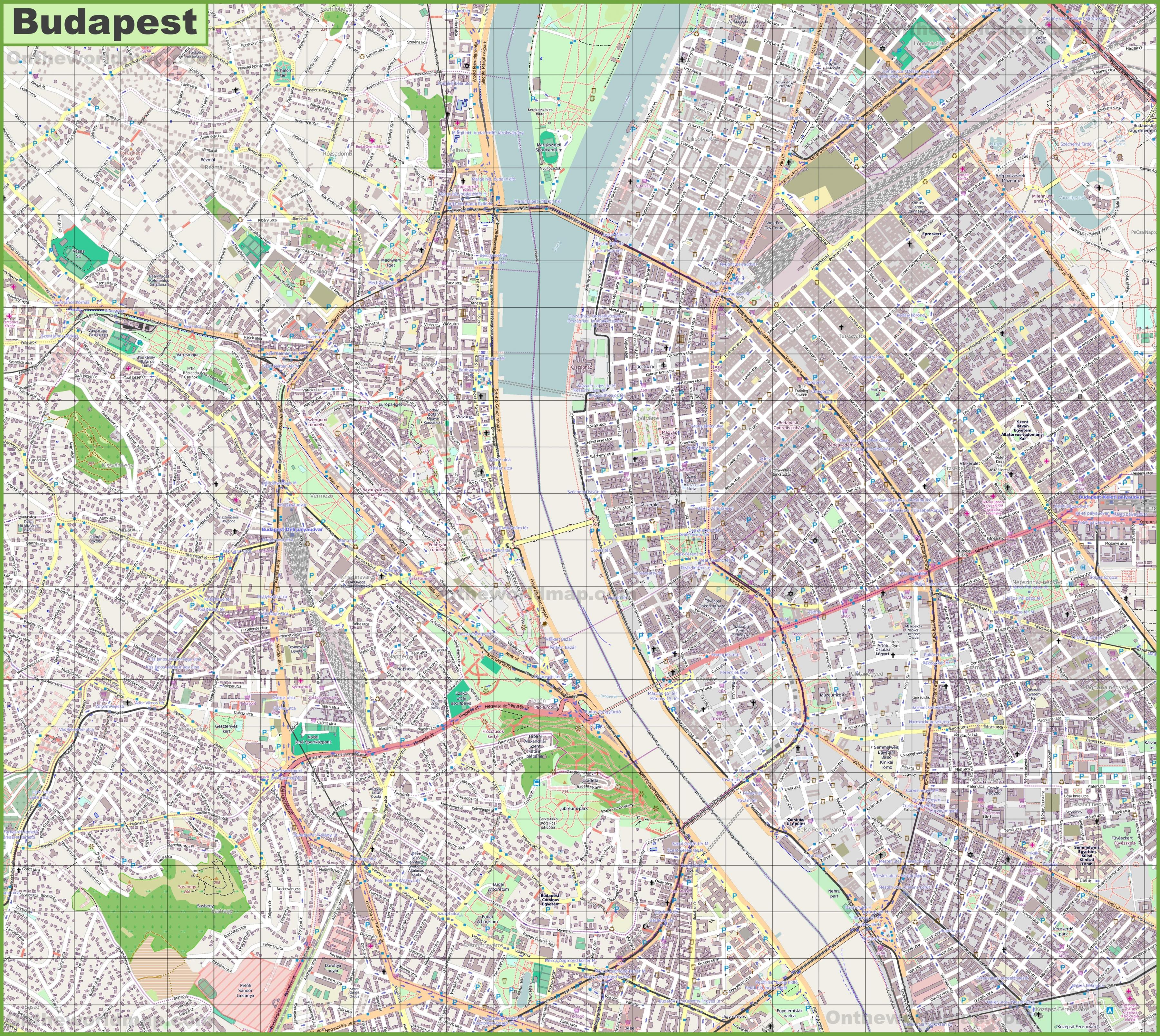
The Budapest streets map shows all street network and main roads of Budapest. This streets map of Budapest will allow you to find your routes through the streets of Budapest in Hungary. The Budapest streets map is downloadable in PDF, printable and free.
Anchored by the riverfront Saint Gellért Square, this increasingly interesting thoroughfare on the city Buda side is fast becoming a hotspot for contemporary culture, but Bártók Béla Boulevard is no stranger to creative characters – about a century ago, the freshly revived Hadik café was a regular hangout for some of Hungary greatest writers, and again today it is frequently filled with artists of various genres. Kazinczy utca as you can see in Budapest streets map, most people associate this slender downtown street with partying, and that makes sense – before the arrival of Budapest world-famous Szimpla Kert ruin pub here in 2004, Kazinczy was a quiet thoroughfare best known as the location of Wichmann Pub (which still serves as a top-notch dive bar occupying the same site for 30 years now). Running perpendicular to adjoining Kazinczy in the Jewish Quarter, Király Street is another formerly unremarkable lane that now bustles with nightlife, much of it centered on the ever-buzzing dining and drinking scene of Gozsdu Udvar.
Stretching deep into District IX from Kálvin Square, Ráday Street as its shown in Budapest streets map, is beloved by many Budapest locals for its profusion of charming eateries, galleries, and laid-back bars lining this pedestrian-friendly lane. When Sziget Festival founder Károly Gerendai decided to launch a fine-dining restaurant in 2008, many Budapest epicures considered Ráday as an odd choice for its location – but after Costes won Hungary first Michelin star in 2010, the neighborhood soon became a culinary hotspot; today diners can find eateries serving all kinds of food from multiple continents. Once upon a time, downtown Pest Váci Street was Hungary version of Rodeo Drive – during Europe belle-époque era, high-society ladies came here for the latest fashions, and it was a place to see and be seen, but nowadays, sightseers mostly fill this long pedestrian-only lane. Although Váci lost some appeal when it became the city primary destination for tourist-trap restaurants and overpriced souvenir shops, it is still worth a walk between Vörösmarty Square and the Great Market Hall, and a few places along the way remain remarkable – Vendetta is popular among locals for its tasty Italian cuisine, while the Art Nouveau-styled Philanthia flower shop is a surviving relic of Váci earlier elegance.
Budapest has renamed streets around the planned site of a leading Chinese university campus to protest an “unwanted” project forced on it by the government of the prime minister, Viktor Orbán. Four street signs at the site now bear the names Free Hong Kong Road, Uyghur Martyrs Road, Dalai Lama Road, and Bishop Xie Shiguang Road, the last referring to a persecuted Chinese Catholic priest. Anker Koz as its mentioned in Budapest streets map, is a small street between Király Utca and Deák Ter in downtown Budapest. It is a popular place among photographers due to the effect of the light on the surrounding buildings. Even if you are not a photographer, it is a cool place to check out and is surrounded by interesting cafes and cute vintage shops. In the first third of the long Andrassy Avenue is the street Liszt Ferenc Ter and Liszt was celebrated with great pomp. If the first statue does not represent the second (main) makes him a first tribute before the music university that bears his name does not end in the spotlight. A small shady park, surrounded by cafes and restaurants, is very nice.
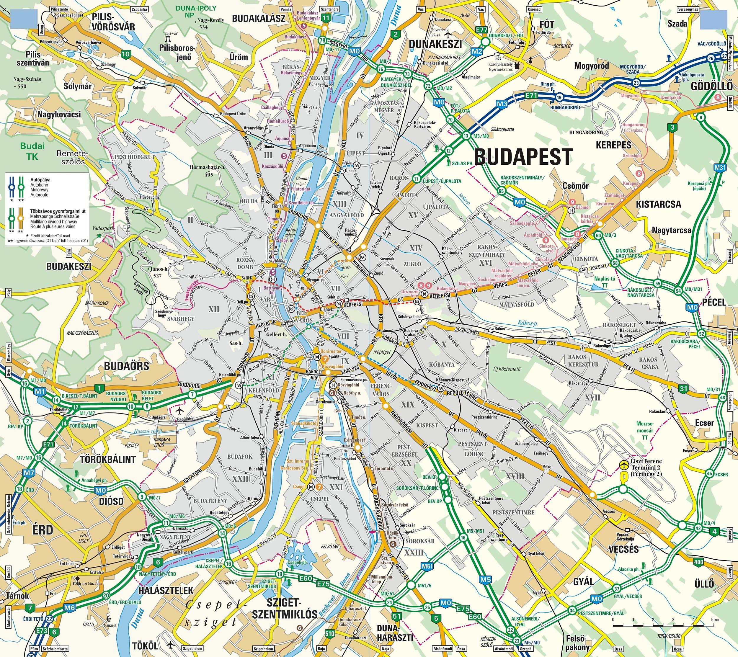
The Budapest roads map shows all road network and highways of Budapest. This roads map of Budapest will allow you to find your routes through the roads and motorways of Budapest in Hungary. The Budapest roads map is downloadable in PDF, printable and free.
Budapest is the most important Hungarian road terminus; most of the major highways end near the city-limits. The road system in the city is designed in a similar manner to that of Paris, with several ring roads, and avenues radiating out from the center. Ring road (beltway) M0 around Budapest is nearly completed, with only one section missing on the west side due to local disputes. Currently the beltway is around 80 kilometers in length, and once finished it will be near 100 kilometers of highway in length as you can see in Budapest roads map.
The bottomline of both the strategy and the decree is to set freight restrictions on the whole territory of Budapest, making transit freight traffic use the M0 motor ring, instead of city roads. In addition, also such roads have been designated through which major industrial and logistics areas can be reached without the need of access permit (hereinafter referred to as “destination traffic roads”) as its shown in Budapest roads map. Zones and destination traffic road sections are designated by traffic signs. Road with restricted traffic: Such roads designated by paragraph 14 (1) r) of the Highway Code (designated by the sign “No entry by Freights”) where freights, tractors, agricultural tractors, slow vehicles exceeding the maximum permitted total weight defined by the sign are not permitted to enter. The access permit for roads with restricted traffic is granted similarly to that of the zones with restricted traffic, however entry fee is not necessary to be paid.
Budapest road network and industrial-trade centres with high delivery demands are not in line with one another. The applied freight zone system took into account the operation of industrial, logistics and trade units constructed on the “brown zone”, due to Budapest spatial structure, in compliance with stipulations of the Freight Transport Strategy for Budapest. The destination traffic routes not crossing residential areas are exemptions from restrictions, which enable unrestricted and free destination traffic between the city boundary and the “brown area” as its mentioned in Budapest roads map.